Back Ebbi-Roud Azerbaijani Abbey Road (carrer) Catalan Abbey Road (vej) Danish Abbey Road (calle) Spanish Abbey Road (Londres) Basque Abbey Road (katu) Finnish Abbey Road (rue) French Abbey Road, Londain Irish Abbey Road Hungarian Abbey Road, London ID
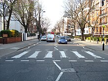
 The crossing in the spring of 2007 | |
| Length | 0.9 mi (1.4 km)[1] |
|---|---|
| Location | St John's Wood, Greater London |
| Postal code | NW8 |
| Nearest Tube station | |
| Coordinates | 51°31′55.4″N 0°10′38.4″W / 51.532056°N 0.177333°W |
| South end | Quex Road, Kilburn |
| East end | Grove End Road St John's Wood |
| Other | |
| Known for | |
Abbey Road is a thoroughfare in the borough of Camden and the City of Westminster in Greater London running roughly northwest to southeast through St John's Wood near Lord's Cricket Ground. It is part of the road B507. The road is best known for the Abbey Road Studios and for featuring on the cover of the Beatles' album of the same name, which was released in September 1969.
- ^ Google (30 October 2015). "Abbey Road, London" (Map). Google Maps. Google. Retrieved 30 October 2015.
© MMXXIII Rich X Search. We shall prevail. All rights reserved. Rich X Search
